NEPTUNE Navigation Software +44(0)118 988 5309
Wrecks, Tides and Streams app
YouTube introduction to Wrecks Tides and Streams app
Follow this link to read the manual
Download the app from the Google Play Store to install on your phone or tablet
Wrecks & Obstructions
+ Slack Water Reports
+ Wrecks Database
+ Obstructions Database
+ Filter by Name, Date
+ Vessel Type and Cargo
+ Image Viewer
+ Drift Diving Data
Tidal Heights
+ Instantaneous Tidal Predictions
+ Calculates Tables and Curves
+ Daily and Monthly Tide Tables
+ Tidal Rate of the Rise and Fall
+ Neap to Springs Meter
+ Primary and Secondary Ports
+ Predictions Include Users Depth
+ Draft & Under Keel Clearance
+ Next & Previous Port Option
+ Sunrise and Sunset Indicator
+ Predictions to the year 2060AD
+ Lunar phases
+ Tide Roll Function
+ Data derived from UKHO sources
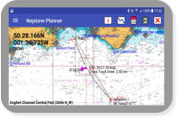
Tidal Streams
+ Raster charts
+ Dynamic Tidal Stream
+ Tidal Stream Roll Function
+ Waypoint Editor
+ Tidal Vectors
+ Interfaces to internal GPS
+ Range Circles
+ Configurable Displays
Wrecks, Tides & Stream
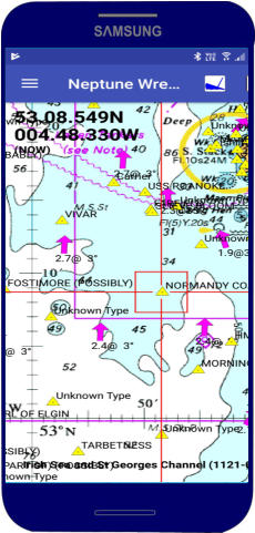
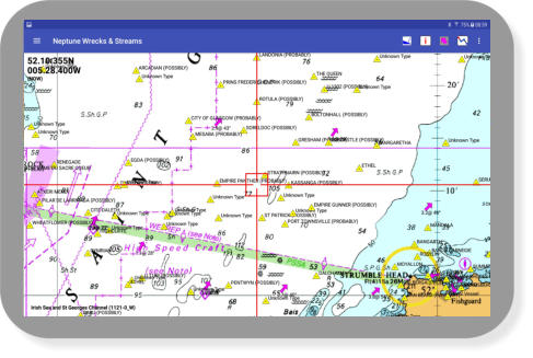
This app contains details and location of thousands of wrecks around the UK and adjacent Continental coastline, just search or select
a wreck and details are retrieved from its internal database, you can use it at sea it does not require an internet connection.
For the diver and fisherman the software produces reports of slack and flood water times and along with its other functions it is very
useful in planning dive times and producing a SOLAS type passage plan.
Ideal for anyone with an interest in our maritime history, this program plots and displays the details, depths, cargo, conditions and
year of loss, with the devices internal GPS you can easily navigate to a location.
With its inbuilt tidal height and tidal stream calculations it predicts the tidal height and tidal stream details around our UK coastline for
many years into the future.
Wrecks, Tides and Streams app Free
Raster charts annually £24.49
Outline charts annually £18.49
System requirements:
Android 5.0 or later


Wrecks, Tides and Streams App
NEPTUNE Navigation Software +44 (0)118 988 5309
NEPTUNE Navigation Software +44(0)118 988 5309

Wrecks, Tides & Streams App
This app contains details and location of thousands of
wrecks around the UK and adjacent Continental coastline,
just search or select a wreck and details are retrieved from
its internal database, you can use it at sea it does not require
an internet connection.
For the diver and fisherman the software produces reports of
slack and flood water times and along with its other functions
it is very useful in planning dive times and producing a
SOLAS type passage plan.
Ideal for anyone with an interest in our maritime history, this
program plots and displays the details of thousands of
wrecks and obstructions around our coastline.
With its inbuilt tidal height and tidal stream calculations it
predicts the tidal height and tidal stream details around our
UK coastline for many years into the future.
Data up to our adjacent continental coastline.
Program Features
Wrecks, Tides and Streams
+ Slack Water Reports
+ Wrecks Database
+ Obstructions Database
+ Filter by Name, Date
+ Vessel Type and Cargo
+ Image Viewer
+ Drift Diving Data
YouTube introduction to Wrecks Tides and Streams app
Follow this link to read the manual
Download the app from the Google Play Store to install on
your phone or tablet
Wrecks, Tides and Streams App
Annually from £18.49
System requirements:
Android 5.0 or later
Tidal Streams
+ Raster charts
+ Dynamic Tidal Stream
+ Wind Grid
+ Tidal Stream Roll
+ Waypoint Editor
+ Tidal Vectors
+ Interfaces to GPS
+ Range Circles
+ Configurable Displays
Tidal Heights
+ Instantaneous Tidal Predictions
+ Calculates Tables and Curves
+ No Annual Updates Required
+ Daily and Monthly Tide Tables
+ Tidal Rate of the Rise and Fall
+ Neap to Springs Meter
+ Primary and Secondary Ports
+ Predictions Include Users Depth
+ Draft & Under Keel Clearance
+ Next & Previous Port Option
+ Sunrise and Sunset Indicator
+ Predictions to the year 2060AD
+ Lunar phases
+ Tide Roll Function
+ Data derived from UKHO source
Neptune Navigation Software Ltd
Unit 11 Diddenham Court
Lambswood Hill Grazeley RG7 1JQ
tel: +44 (0)118 988 5309