Neptune Navigation Software Ltd
PO Box 5106 Riseley Berkshire RG7 1FD
sales@neptunenavigation.co.uk
tel: +44 (0)118 9885309

NEPTUNE Navigation Software +44(0)118 988 5309
Outline Planner Program
Program Features
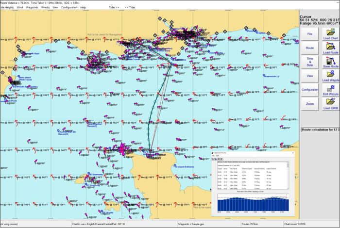
Course to Steer Calculations - Route Optimised Departure - Course over Ground - Dynamic Tidal Stream - Wind & Polar Plot - Animate Routes - Tide & Water Track Roll -
Track Plotter - Waypoint Editor - SOLAS Compatibility - Course and Tidal Vectors - Cross Track Error displayed - Interfaces to GPS - Interfaces to AIS engine - Tidal Stream -
Incorporates Tides Program - Range Circles - Configure Displays - Tidal Data - Tidal Stream Reports and Graphs - Grib Files for Internet Weather - Google Earth COG &
Tracks - Select Charts using Thumbnails - Zoom to Rectangle - Copy Screen and Route buttons - Snap to Waypoints - GPX for Waypoint and Route - Waypoint Transfer GPS
Receivers & Plotters via NMEA 0183 - AIS Aid to Navigation Beacons - Wrecks data
New Features for Outline Planner Plus version 11.1.0
Download Outline Planner version 11.1.0 demo
Features for Outline Planner Plus version 11
Automatic chart change using Mouse scroll wheel
Waypoint and Route Management
Waypoint and Route compatibility with modern GPX format (i.e. Garmin or Open CPN)
Waypoints and routes compatible with Neptune App.
UK Wrecks and Obstructions with details of depths, history, cargo etc
Neptune Outline software including a chart portfolio of your choice £69.00
Additional portfolios of charts £19.00 each
Upgrade Outline Planner program to version 11.1.0 £25.00
Upgrade portfolios of charts £6.00
System requirements:
Recommended - Windows 8 and Windows 10
(Processor speed 1.6 GHz , Ram 2Gb, Typical HDD Space 300Mb)
This program uses all the same features as the Plotter Planner Plus but uses the Neptune Outline charts. This program was designed for customers who have plotters
but require the tidal course calculation from the Tides, Streams and Wind (GRIBS) etc.
This remarkably easy to use Outline Planner offers Course Calculations from inbuilt Tidal Height, Tidal Streams and Wind Routines producing Course to Steer, Course
Over Ground and Optimised Departure. GPS Track Plot, AIS, Waypoint Manager. Incorporates a Tide Height Program. Grib Files, Google Earth, Animate Course Over
Ground, SOLAS compatible, and Polar Plots.


Outline Planner Software
NEPTUNE Navigation Software +44 (0)118 988 5309
NEPTUNE Navigation Software +44(0)118 988 5309

Program Features
Course to Steer Calculations - Route Optimised Departure -
Course over Ground - Dynamic Tidal Stream - Wind & Polar
Plot - Animate Routes - Tide & Water Track Roll - Track
Plotter - Waypoint Editor - SOLAS Compatibility - Course and
Tidal Vectors - Cross Track Error displayed - Interfaces to
GPS - Interfaces to AIS engine - Tidal Stream - Incorporates
Tides Program - Range Circles - Configure Displays - Data
derived from UKHO sources - Tidal Stream Reports and
Graphs - Grib Files for Internet Weather - Google Earth COG
& Tracks - Select Charts using Thumbnails - Zoom to
Rectangle - Copy Screen and Route - Snap to Waypoints -
GPX for Waypoint and Route - Waypoint Transfer GPS
Receivers & Plotters via NMEA 0183 - AIS Aid to Navigation
Beacons - Wrecks data
New Features for Outline Planner version 11.1.0
Touch screen or mouse input.
New menu layout.
Ease of chart selection.
UK Wrecks and Obstructions with details of depths, history,
cargo etc.
Neptune Outline including a chart portfolio of your choice
£69.00
Additional charts £19.00 each
System requirements:
Recommended - Windows 8 and 10
(Processor 1.6 GHz , Ram 2Gb, Typical HDD Space 300Mb)
Outline Planner Software
This tidal passage planning and navigation program using
Neptune's established algorithms calculating course to steer,
course over ground and optimised departure times all taking
into account tides and tidal streams from inbuilt tidal data.
After a calculation the results are readily available on screen
with the vector plot construction shown so that navigators
can cross check their chartwork.

Neptune Navigation Software Ltd
Unit 11 Diddenham Court
Lambswood Hill Grazeley RG7 1JQ
tel: +44 (0)118 988 5309